Annapurna Circuit Trek Map Every Trekker Should See for 2026 and 2027
Annapurna Circuit Trek Map Every Trekker Should See for 2026 and 2027
Updated on June 05, 2026
The Annapurna Circuit Trek takes you from lush subtropical forests to almost desert-like landscapes in the trans-Himalayan region rain shadow areas in and around the Thorong La Pass (5,416 m) in stark contrast to snow-capped mountain peaks; hence, it is one of the most diverse long-distance high-Himalayan treks in the world. As bookings are open for 2026 and 2027, the Annapurna Circuit Trekking Map becomes more important than ever.
Whether it's revealing the hidden gems of the Annapurna Trekking region, famous for the iconic Annapurna Base Camp Trek and short Annapurna Panorama Trek, Annapurna Machhapuchhre Trek, and Annapurna Dhaulagiri Trek, or navigating the tough terrain or simply understanding the geography, the Annapurna Trek Map, Annapurna Circuit Trail Map, if you are planning to take a round of the 10th highest mountain in the world, Mt. Annapurna (8,091 m), gets essential.
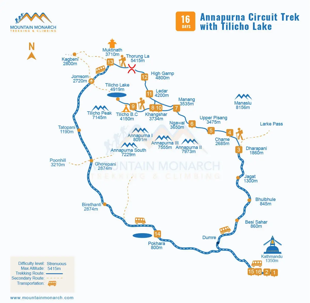
Overview of the 16 Days Classic Annapurna Circuit Trek Itinerary
The hiking journey for the Annapurna Circuit Trekking Itinerary begins on the 4th day with a trek to Chame, following the 1st day of arrival, the 2nd day of sightseeing at Kathmandu's UNESCO World Heritage Sites, and the 3rd day of driving to Besishar, Bulbhule, and then Dharapani. Thereafter, you head deeper into the Annapurna Conservation Area, the largest conservation area in Nepal, staying and walking past several traditional mountain villages
Soon you will be moving forth in the trans-Himalayan region, which is one of the rain shadow areas of Nepal, located behind the majestic Mount Dhaulagiri (8,167 m, the 7th highest mountain peak in the world) and Annapurna (8,091 m, the 10th tallest mountain peak worldwide). As indicated on the map, Thorong La Pass, at an elevation of approximately 5,416 m above sea level, is both the most rewarding and the most challenging phase.
Major highlights of the Annapurna Circuit Trekking journey in Nepal on the map
Other than the epic mountain views from start to end, the standard around the trek to the Annapurna route, i.e., the Annapurna Circuit trek with the Tilicho Lake map, includes major highlights such as traversing through the diverse landscapes and climatic zones, rich local culture and traditional villages, and of course one of the high mountain passes in Nepal, Thorong La Pass (5,416m) that connects the Manang and Mustang Valleys.
Following the classic Annapurna Circuit Trek itinerary from Mountain Monarch, the journey does not stop here; you hike up to both the sacred alpine lake of Tilicho, also regarded as one of the world's highest lakes, and the Muktinath Temple, the sacred shrine of the lord Vishnu that is further taken as one of the Char Dham sites spread across the globe. With an option for camping as well, if you choose, overall it offers you a teahouse trek with the true wilderness.
Why do you need the classic Annapurna Circuit trek map?
An Annapurna Circuit trek map with distance has multiple purposes. It is a must to understand the geographical condition of the region you are journeying to, including daily walking distance, altitude gain, and finding the teahouses' locations. Though the trekking routes are well established, such as the Everest Base Camp Trek, Everest Three High Passes Trek, and the Gokyo Lakes Trek, the unpredictable weather and side trips can be confusing.
Where the Annapurna Circuit trekking map becomes extremely helpful to plan alternative routes and evacuation points in case of emergency, just like knowing the best landmarks for side treks, whether to go to Tilicho Lake, Ice Lake, Ghorepani Poon Hill, or continue hiking up to the restricted Manaslu Conservation Area and its routes such as the classic Manaslu Circuit Trek, the Nar Phu Valley Trek, or the Tsum Valley Trek and also plan much-needed acclimatization.
Major stopping points as per the Nepal Annapurna Circuit map
Yes, depending upon the specific Annapurna Circuit Trekking itinerary, such as whether it is short, standard, or long, and combined with the Annapurna Base Camp with packages such as the Annapurna Circuit with Base Camp Trek, the stopping places may vary. Often in general, the Annapurna Trekking maps denote Chame, Pisang, Ngawal, Manang, Khansar, Tilicho Base Camp, Shree Kharka, Ledar, High Camp, and Muktinath.
At a higher altitude than the places you hike through that day, you can expect more open and close-up views of mountains, and it is often also chosen due to its proximity to nearby notable landmarks. Such as from Manang, the infamous Milarepa Cave is a few hours of walking; so are the Ice Lake, Praken Gompa, Braga village and monastery, and also Bhojo village. They have better views and are also both culturally and spiritually significant.
Annapurna Circuit Trek Map With Distance: How long is the daily walk?
On choosing the short Annapurna Circuit hiking journey, please be clear that you may have to cover long distances and also walk for longer hours. But if you are planning to stick to the standard Annapurna Circuit Hike itinerary of 16 days, generally, you hike 5-8 hours on a daily basis. Some days include steep upchill climbs, and so does downhill walking, along with rocky and snowy trails, especially in and around the Thorong La Pass.
5,000 m above sea level, where Himalayan weather is known for being notoriously unpredictable, though the distance covered may not be that long, high altitude and challenging location often make it both physically and mentally demanding, as cited in the classic Annapurna Circuit trek map. Either way, overall, you cover a larger distance compared to several other high altitude treks in Nepal, about 160 and 230 km (100-143 miles).
The standard Annapurna Circuit Map via Thorong La Pass (5,416 m) with a side trip to Tilicho Lake
What is the highest point of the trek as per the Annapurna Circuit elevation map?
Thorong La Pass, measuring about 5,416 m above sea level, is the maximum elevation gain one experiences during the Annapurna Circuit hike. Beginning walking from as low as 1,860 m at Dharapani to reaching this point, the Annapurna Circuit elevation map keeps you aware of what's coming for you on the journey ahead and helps you decide for yourself whether you are ready for it or not, and prepare accordingly, such as an extra night in Manang.
Or once you are on the Annapurna Circuit hiking trail, you do not rush the steps. Maintain your pace, and keep in mind that you are not in competition with anyone but yourself, and listen to your guide. After extreme fatigue, altitude sickness is the main concern, which often requires assistance, as, if not taken care of on time, it can lead to fatal conditions like HACE and HAPE, where a trekking map to Annapurna provides rough ideas, and you need to be extra conscious.
Is the Tilicho Lake extension on the map of the Annapurna Circuit trek worth it?
Located at an elevation of 4,919 m above sea level, Tilicho Lake is more than just an alpine lake. Originating from the melting of the snow at the center of the sky-towering, snow-capped peaks and serving as one of the best-kept secrets and incredible natural amphitheaters with some of the best scenery, it is also a place that is held sacred by both the Hindus and Buddhists across the world, with a direct link to Hindu epics like the Ramayana.
It is believed to be the place where the sage Kak Bhusundi (who is said to have witnessed the Ramayana 11 times) first narrated the epic of the Ramayana to the king of birds, Garuda (the carriage/vahana of Lord Vishnu). That is why a large number of devotees visit the place for bathing in the lake water to clean karma and earn merits, especially during the Janai Purnima. It's worth a hike, and add the Annapurna Circuit trek with the Tilicho Lake map.
Best Times and Variations on the Map
Even with the most up-to-date and best Annapurna Circuit trekking map available in the market, the wrong time can make it tougher for you to make the best out of the high Himalayan trip. Therefore, it is a must that you know when the best time is for a trekking journey to take a round trip of Mount Annapurna, which is, of course, spring and autumn, from March to May and September to November. These times of the year feature the most favorable weather.
The temperature is mild, the skies are clear, and visibility is also excellent. Into the trans-Himalayan rain shadow zone, though summer (monsoon) trekking is also manageable and regarded as one of the best summer alternative treks in the lower region, you can still come across heavy rainfall. In winter, it can get unbearably cold at higher altitudes, and along with the Nepal Annapurna Circuit, you may need to be prepared for extra seasonal challenges.
Trekking Permits and Map Planning: How to prepare?
Yet another important paper or document essential after a map for a trekking and climbing journey in Nepal, inside its national park, conservation, and restricted high-round Himalayan trip encircling Mt. Annapurna and its ranges is a permit. You will need at least two permits, the Annapurna Conservation Area Permit (ACAP) and the standard Trekkers’ Information Management System (TIMS) Card.
As per the recent update on 2026, while most of the Nepal trekking permits are fully online, the best to do is to purchase a comprehensive Annapurna Circuit hiking package from one of the reputed travel, trek, and climbing companies, such as Mountain Monarch. As we manage all the essential Annapurna Trek permits along with the map of the Annapurna Circuit trek, a hassle-free experience is our guarantee. Book now!
Digital vs. Physical Annapurna Circuit Trekking Maps: Which one is better?
While many may prefer digital maps for the Annapurna Circuit Trekking journey for their real-time location tracking, offline navigation, elevation data, and also the distance calculations, it is crucial for you to understand that batteries run out quickly at high altitudes due to cold, so the most reliable option is a printed Annapurna Circuit Trek route map. You can find plenty of them at the vibrant tourist town of Thamel.
Or you may choose to print them out from our website. They are useful during electronic device failure for discussing plans with guides and provide an easy trekking route overview, a reliable backup. So consider keeping one with you, safely protected from water. When booking with Mountain Monarch, we provide one porter per trekker and also a licensed guide who keeps you informed on daily route updates from landslide-prone areas to places with high-altitude risks.
Conclusion
The reliable Annapurna Circuit Trekking Map provides you with a better understanding of hiking distance, elevation, acclimatization, side trips, and also optional routes to take if there are risks on the initial trail you were planning to follow. Whether digital GPS or printed with the classic Annapurna Circuit Trek Map, you are set for a memorable odyssey, including for the years 2026 and 2027. The route planning is proper and safer.
Knowing what to expect means you can trek with confidence, especially when you are supported by well-trained and experienced mountain guides and operators from Mountain Monarch, which has more than two decades of experience in travel and tourism. With us, you are in the right hands. The Annapurna Circuit elevation map is to save your lungs, and Mountain Monarch is to experience the best that the Himalayas have to offer. Book now!