Mapping the toughest loop in the Everest Himalayas: The Everest Three Passes Trek Map
Mapping the toughest loop in the Everest Himalayas: The Everest Three Passes Trek Map
Updated on February 27, 2026
Among several Everest treks in Nepal, such as the classic Everest Base Camp Trek, Everest Circuit Trek, and Gokyo Lakes Trek, the Everest Three High Passes Trek, including the crossing of three iconic high mountain passes of the Everest region, stands out as the ultimate high-altitude adventure. A dream journey worth adding to your bucket list for 2026 and 2027 for someone seeking a more demanding and less trodden circuit.
Therefore, to make it safely and successfully through Kongma La, Cho La, and Renjo La Passes, the Everest Three Passes Trek Map serves as more than just a navigation tool. One of the finest high-altitude trekking trails in Nepal, a perfect destination to test your stamina, endurance, and strength before beginning a mountaineering journey, here is the importance of the Everest Three Passes Loop Trail Map you must know.
Overview of the Everest Three High Passes Trekking Trail
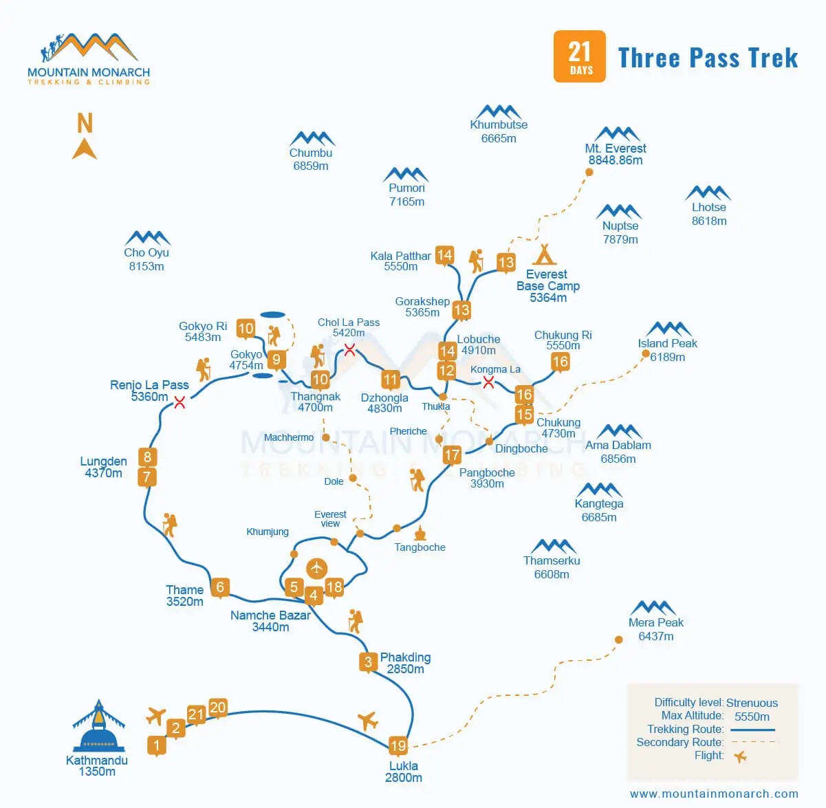
Forming a circular loop connecting three of the major high-altitude passes, the Everest Three High Passes Hike begins traditionally with a mountain flight to Lukla from Kathmandu or Ramechhap, Manthali. In no time, you will be off the beaten path, in the parts of Khumbu that are known to only a few. As you can also see on the Everest Three Passes Loop Trail Map, the journey progresses through Thame, Lungden, and Gokyo Ri.
You cross the first pass, Renjo La Pass. Then you make it to Cho La Pass and Kong Ma Lass Pass after Everest Base Camp (5,364 m). The walk is 5,000 m above sea level for several days, and long hours of walking with sections that can be considered more technical than those found on Himalayan treks in Nepal, such as the Annapurna Sanctuary Trek and the Langtang Valley Trek, allow you to get a taste of mountaineering.
What are the major highlights on the Three Passes Everest Trek Map?
There’s a lot to do and see while on the Three High Passes Trek in the Everest Himalayas. Inside the Sagarmatha National Park boundaries, which is also one of the UNESCO World Heritage Sites, home to a diverse range of flora, fauna, and Sherpas (also called the Tigers of snow for their extraordinary mountaineering skills and adaptability), you enter deep into the Everest trekking and climbing region at the heart of several majestic mountain ranges.
Whether you choose the clockwise or anticlockwise route, the map for trekking the Everest 3 passes major highlights include thrilling high suspension bridges, lush forests to shimmering glacier systems (Ngozumpa Glacier and Khumbu Glacier), and several monasteries with a mythical vibe; a twist in each step from lush subtropical forests to barren land in stark contrast to the snow-capped peaks; and Mt. Everest dominates the sky horizon.
Why is the map for trekking the Everest 3 Passes crucial?
While it's a win-win with the equal effort it demands, the Everest Three High Passes Trekking Trail also rewards you immensely, especially for those seeking an amazing blend of adventure, achievement, scenery, culture, and nature. In the Himalayas, you never underestimate the inherent risks that come with it, and the Three Passes Everest Trek Map is what gives you a rough idea about what awaits you in your journey ahead.
Trail junctions, alternative routes, the Everest Three Passes total distance, Everest high pass elevations, glacier crossings, major villages, teahouses, and, in case of emergency, the better exit route; a proper Everest Three Passes Loop Trail Map helps you make up your mind for best-to-worst scenarios, including sudden changes in weather from sunny to windy just in the blink of an eye and snowy mountain pass crossings regardless of the season.
Understanding the Remote Everest Trekking Loop Route: Clockwise vs. Anticlockwise
Yes, there are two ways you can complete the Everest Three High Passes Trek: by following the clockwise route and the anticlockwise route. As per the map for trekking the Everest 3 Passes, after a short and scenic flight to Lukla from Kathmandu, those on the clockwise trail head towards Namche Bazaar before crossing Renjo La Pass (5,360 m), Cho La (5,420 m), and then finally the highest, Kong Ma La Pass (5,535 m).
Meanwhile, the anticlockwise Everest Three Passes trekking route takes you through Dingboche, where you first cross Kongma La, followed by Cho La and Renjo La. As the elevation gain is gradual through the Gokyo Valley and Everest Base Camp before the technical sections later on to Kong Ma La Pass, many prefer clockwise; however, as per the golden rule, hike up and sleep low, so anticlockwise might be considered better for acclimatization.
A Glimpse into the Khumbu Region Trekking Map to Three Passes
The standard itinerary and the Everest Three Passes Trek Map guide you through three iconic valleys of the Everest Himalayas: Gokyo, Khumbu, and Imja. Kathmandu, flight to Lukla, Phakding, Namche Bazaar, Thame, Lungden, and then on to the Gokyo Valley, which is home to the turquoise lakes of Gokyo and one of the high peaks, Gokyo Ri, via the Renjo La Pass. From here, then, you enter the legendary Khumbu Valley.
As you cross Cho La Pass, as per the Everest Three Passes Trekking Itinerary of 21 days from Thangnak, you make it to Dzongla before you arrive at Lobuche, past Thukla. From Lobuche, you head to Gorak Shep, Everest Base Camp, and Kala Patthar, then trace the trails to Imja Valley via Kong Ma La Pass, hike up to Chhukung Ri, descend through the villages of Pangboche and Namche, and return to Lukla from Chhukung.
A standard map for the Everest 3 Passes Trek in Nepal
Everest High Pass Elevations Explained by Map
While Lukla, at an elevation of 2,860 m above sea level, is the typical Everest Three High Passes Trek starting point, and the highest point is at Kala Patthar, at around 5,644 m above sea level, like on the classic Everest Base Camp Trek, several days of hiking at 5,000 m above sea level is what makes it a challenging endeavor in comparison to the similar kinds ofAnnapurna Circuit Trek and the Manaslu Circuit Trek.
Although the difference from starting to the highest point is about 2,700 m, as you make it to three of the major high mountain passes, peaks, and also the Everest Base Camp (EBC), all at high altitude with a lower presence of oxygen, including constant ascents and descents, proper acclimatization becomes non-negotiable. On the Khumbu region trekking map, acclimatization stops are shown at Namche, Lungden, and Gokyo.
How far is the Everest Three Passes Trekking from Kathmandu?
Like any other Everest trek, the Everest Three Passes Hike officially begins from Lukla, which from Kathmandu is about 135-140 km (84-87 miles) away, in about a 30-35 minute flight, depending on the air traffic of the day. It often gets busier in the peak trekking seasons of spring and autumn, for which the flyover is diverted from Ramechhap (Manthali). Then, in about three weeks, you cover approximately 160-170 km.
Or you may choose to extend the journey up to Island Peak or Lobuche East Peak. Regardless, the best Everest Three High Passes Trek Map is the one that allows you to calculate the realistic Everest Three Passes total distance and Everest high pass elevations, where even 10 km can feel like 20 km, especially due to the high altitude, unpredictability of the Himalayan weather, and colder early mornings and nights, regardless of the seasons you are trekking in.
Why are acclimatization days separated on the Three High Passes Trek Nepal Map?
On rapid ascent to higher elevations without proper acclimatization, the body fails to adapt to the arduous Himalayan surroundings, and anyone can suffer from the symptoms of altitude sickness, also referred to as acute mountain sickness (AMS), including on the Three High Passes Himalayan Trip. Therefore, to ensure you have a hassle-free journey and also minimise the potential risk of AMS, there are buffer days.
The proven tip is to hike up and sleep low; therefore, whenever or wherever you get a chance, you may take an early morning hike to nearby high-altitude peaks or landmarks, and in your spare time, stroll around the villages and rest adequately. For this remote Everest trekking loop, according to the 21 days Three Passes Everest Trek Map, the spare days are villages which beside being at the center of high peaks, are culturally significant as well.
Safety Tips When Reading the Everest Three Passes Loop Trail Map
No wonder a map is one of the must-have essentials for a better approach to high-altitude trekking and climbing; along with this, there are several things one can do to ensure a safer, more strategic, immersive, and seamless adventure. Besides using the Khumbu region trekking map for the Everest Three High Passes Trekking to make the best out of this high Himalayan expedition-like trip, start earlier on pass crossing days.
To avoid strong afternoon winds, do not spend more than 30 minutes atop any high-altitude landmarks 5,000 m above sea level. Maintain your pace; you are not in competition with anyone, and respect the Himalayas. Eat healthy; the best is to stick to whatever vegetarian meals are available, drink plenty of water, and most importantly, listen to your body and guide. Take a break when needed and stay optimistic, as it is a life-changing journey for a reason.
Is this Everest Three High Passes Himalayan Trip suitable for you?
Yes, the Three High Passes Trekking in the Everest is worth everything, especially for those who are in a dilemma on what adventurous things to do next after mid, mild, and/or short treks in Nepal, such as the Annapurna Panorama Trek, the Annapurna Dhaulagiri Trek, and the Langtang Gosaikunda Lake Trek, but are not yet ready for peak climbing. It is ideal for seasoned trekkers seeking moments of achievement, adventure, and serenity.
A less crowded high-altitude trekking in Nepal it is, and with the Three High Passes Trek Nepal Map, there is ease in navigation. Having said that, if you are a first-timer, it is best done only after proper preparation of at least 2-3 months, or at first, it is good to gain experience of Himalayan trekking with less demanding routes. Otherwise, the Everest Three Passes Hike is also a heaven for photographers keen on panoramic Himalayan views.
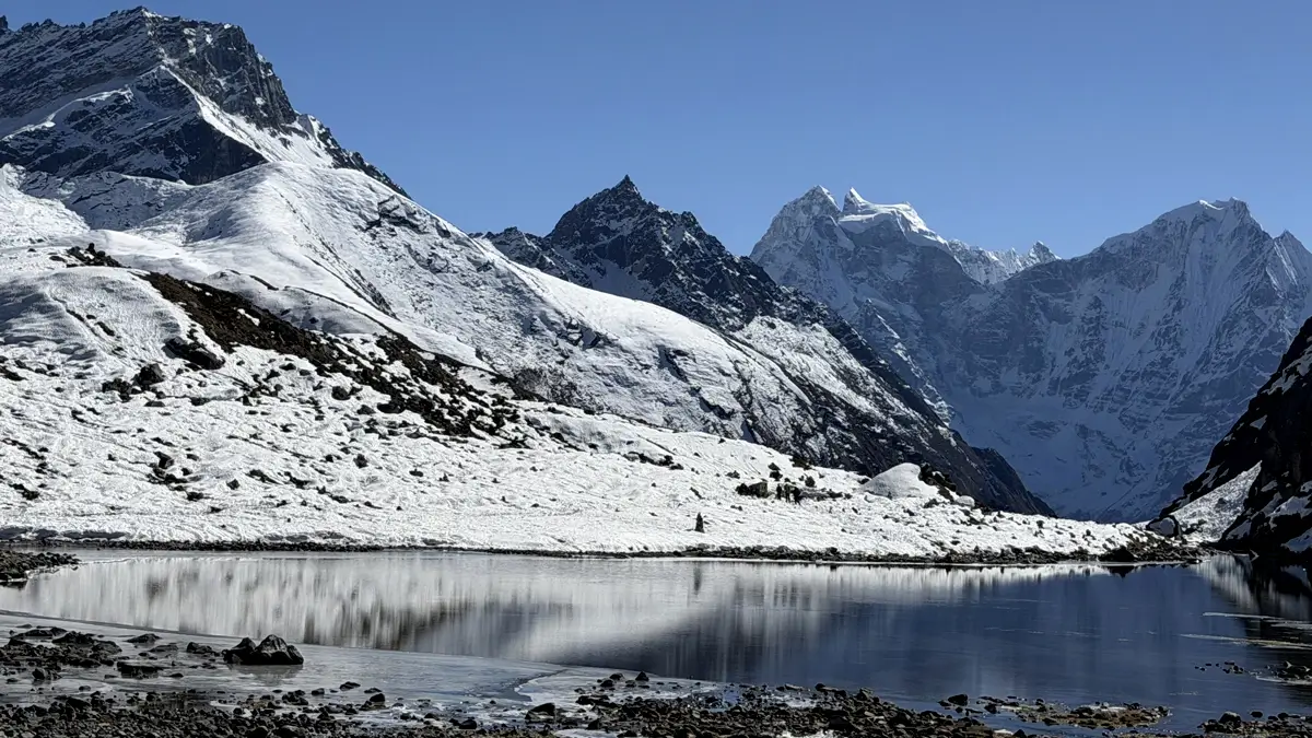
Everest Gokyo Lakes (around 4,700 m to 5,000 m)
Conclusion
The Everest Three Passes Trek Map is more than just a piece of paper; it is a blueprint to successfully navigate one of the most exciting mountain adventures in Nepal. For those on solo trekking without a guide, it is your companion and key to unveiling the mysterious, isolated realms of Everest. Or you may choose to book our comprehensive Everest Three High Passes Trekking packages for 2026 and 2027.
Our Remote Everest trekking loop cost includes all the transportation, meals, lodges, guides, and also essential trekking gear and equipment, followed by 1 porter per guide, and standby oxygen required for an enhanced trek experience. An experienced Himalayan guide, along with leading the journey, also shares insights into local terrains and safety tips. Bookings are now open for 2026 and 2027; contact us now to reserve your seat!