Understanding the Mera Peak Route Map: Plot a Successful Climbing Journey
Understanding the Mera Peak Route Map: Plot a Successful Climbing Journey
Updated on January 16, 2026
Mera Peak climbing is one of Nepal’s most popular trekking peaks in the Everest Himalayas, the kingdom of the top of the world, Mount Everest (8,848.86 m), where Mera Peak serves as a perfect practice ground. If you are planning 7,000m and 8,000m peaks for the future, it is a must that you acquire mountaineering experience, and the Mera Peak Expedition is just the right Himalayan expedition to begin your climbing.
But even it requires thoughtful preparation. It may have been considered beginner-friendly, but the least you could do is never underestimate what the Himalayas are capable of doing, so here’s the Mera Peak Trek Map to visualize the potential challenges and rewards, the role of Mera Peak Base Camp, High Camp Mera Peak, and other considerations, including safety concerns like Mera Peak deaths, which have been rare, but the risks are still there.
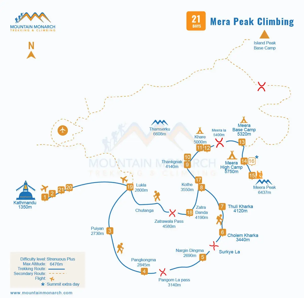
Through Puiyan, Nargin Dingma via Pangkoma and Cholen Kharka, Tagnang via Narging and Pacha Pokhara, and finally Khare, the Mera Peak Base Camp, this Mera Peak Trek itinerary remains less busy even during the peak trekking and climbing seasons in Nepal: spring and autumn. The 21 days for the Mera Peak Climbing Itinerary ensure proper acclimatization, full exploration, and a hassle-free trip. Bookings are open for 2026 and 2027.
Mera Peak Height and Location
Mera Peak is situated in the Solukhumbu region of Nepal, east of the main Everest trekking corridor and south of Everest (Sagarmatha in Nepal and Chomolungma in Tibet) in the isolated Hinku Valley between the Makalu Barun National Park and the Sagarmatha National Park, which is further listed as one of the UNESCO World Heritage Sites in the country. The official Mera Peak Height is 6,476m/21,247ft above sea level.
Making it the highest trekking peak in Nepal. But since it is still not technical, it is still classified as a “trekking peak.” However, it is a must that you respect altitude and prepare accordingly. Strong physical and mental conditioning is non-negotiable, as is proper acclimatization to tackle the zones with low levels of oxygen and a good Mera Peak route map for trekking and climbing, marking the elevation gain.
A standard 21 days Mera Peak climbing map
Why does the Mera Peak Route Map matter?
The Mera Peak map for climbing is beyond a line from point A to point B. It also helps you understand the major pros and cons of the region and the Mera Peak trekking high-altitude profile and align the expectations with reality. It is a much-needed framework and a strategic blueprint for a safe and successful Mera Peak summit, minimizing the surprises on the mountain. Here’s the need for the Mera Peak map for climbing in brief:
Understand the daily Mera Peak elevation gains and losses and plan acclimatization accordingly.
Identify major stops like key villages, rest days, and emergency exit points, especially when walking through landslide-prone areas.
Make up one’s mind for glacier crossings, high mountain pass crossings, and challenging steep ascents.
Locate Mera Peak Base Camp and High Camp Mera Peak, and plan logistics accordingly.
Knowledge of possible side trips and hikes, etc.
Day by Day Mera Peak Route Map Breakdown
Lower Mera Peak Trekking section (Lukla to Kothe): The Mera Peak Trek map traces the rhododendron forests, bamboo groves, and remote Rai and Sherpa villages on the initial sections. The elevation gain is gradual and moderate, allowing a more natural adaptation. Maps mark teahouses and camping areas of the Hinku Valley.
Middle Phase on climbing journey to Mera Peak (Kothe to Khare): As you leave Kothe behind and move to higher altitudes all the way to Khare (the Mera Peak Base Camp), the landscape transitions from lush greenery to rocky moraines, glacial-fed rivers, and sparse villages, making Khare a major acclimatization hub on almost every Mera Peak map for climbing.
Mera Peak Base Camp on the Route Map: Gateway to Mera Peak Expedition
At an altitude of approximately 5,000 m above sea level, Khare is the Mera Peak Base Camp, from where the actual climbing journey begins, and the climbing map for Mera Peak also marks the beginning of expedition-style adventure, staying in tent camps from the teahouse high Himalayan trekking. Unlike Everest Base Camp, it is not a permanent settlement but a temporary camping site that your trip organizer, such as Mountain Monarch, sets for you.
Amid boulders and moraines, Sherpa Mountain Guide provides you with training to enhance your climbing skills. It is to increase the Mera Peak Summit success rate, also symbolizing the transition from trekking to climbing. So we expect you to be attentive in session and later on, chill out and relish the sunrise and sunset views of glowing Hinku and Honku Himal. Mera Peak Base Camp is a staging ground to practice ice axe skills and others.
High Camp Mera Peak: The Launching Point
The Mera Peak High Camp lies 5,800 m above sea level. Nights here can be extremely cold, with temperatures often subzero above the glacier on a rocky ridge, also serving as one of the best viewpoints in the Everest trekking and climbing region. Strong winds are common; you continue the golden rule: hike up, sleep low, and wait for the day with the optimal weather to begin the Mera Peak summit push.
On the Mera Peak Climbing Map, from Base Camp to High Camp is marked as a narrow and exposed trail; be cautious of high altitude, as its effect is significantly visible here. Though it may not be technical, discipline, patience, and professional guidance are essential. Listen to your body and follow the lead of your Sherpa mountain guide. Your health, safety, and satisfaction mean everything to them, so you stop when they say so.
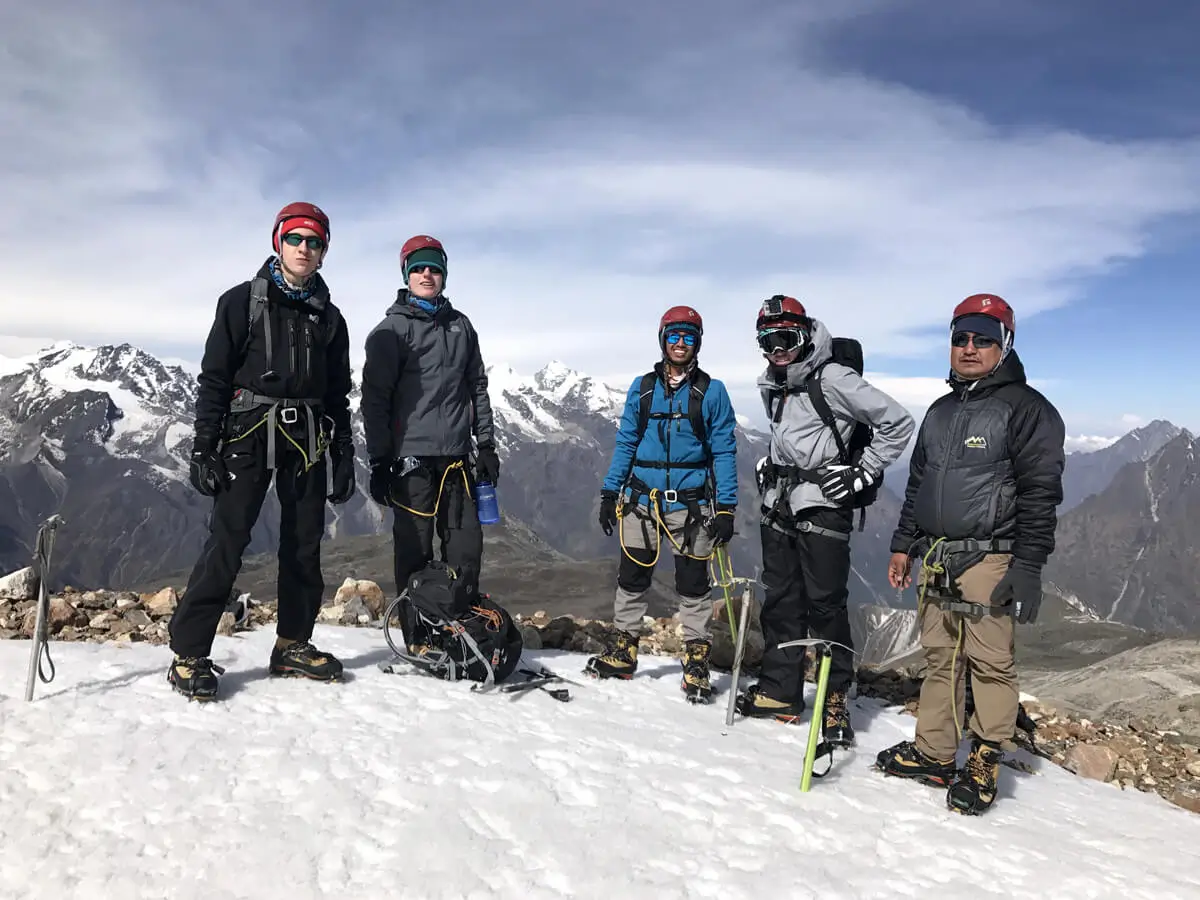
Mera Peak Climbing Group of Mountain Monarch
Mera Peak Climb Summit Day: Reading the final section of the Mera Peak Trek Map
From High Camp Mera Peak, the summit begins early in the morning, even before dawn, around 2 am to 3 am. As per the Mera Peak trekking and climbing map, the ascent is gentle but long, with snow slopes, glacier walking, and approximately 700 m of elevation gain to Mera Peak's height of 6,476 m; you put all the training and mountaineering skills into action. Use of crampons, ice axes, harnesses, ascenders, and sometimes climbing ropes.
It is both the most challenging and rewarding phase. Especially the last 30-50 m to the central Mera Peak summit, involving a steep snow slope, and once you reach the top, a great sense of adventure and achievement with a 360-degree view of at least five of the mountain peaks measuring 8,000 m above sea level: Everest, Kanchenjunga, Lhotse, Makalu, and Cho Oyu. Major highlight of the Mera Peak trekking map for a reason.
Mera Peak Climbing Safety and Deaths: Navigating the Risks
It is only fair that people fear the unknown, including Mera Peak deaths. Which, in fact, have comparatively low fatality rates as compared to technical Himalayan expeditions, the Baruntse Expedition, the Mount Manaslu Expedition, and the Mount Everest Expedition itself. The major concern here is the high altitude that can lead to acute mountain sickness (AMS), HACE, and HAPE, life-threatening conditions if not taken care of on time.
Follow the Mera Peak route map for trekking and climbing, and plan a proper acclimatization schedule. Avalanches and falls on icy sections are also possible, so be extra careful as marked on the Mera Peak Trek Map. Our professional guide enforces rest days, oxygen monitoring, and use of Diamox as needed. We provide all solo and group climbing gear and equipment, oxygen cylinders on standby, and weather monitoring to minimize risks.
Tackle Altitude challenges on the climbing journey to Mera Peak
Beginning from the altitude of 2,860 m above sea level at Lukla to reaching Mera Peak height at 6,476 m above sea level, by now you must have been well aware that high altitude is the major concern. Even with the straightforward Mera Peak trekking and climbing route, anyone, regardless of their experience, age, or fitness, can encounter symptoms of acute mountain sickness (AMS), generally called altitude sickness.
To prevent it, the detailed climbing map for Mera Peak highlights gradual ascent profiles, acclimatization days, and also logical camping spaces. Avoid rapid ascents, do not skip meals, eat healthy, stay hydrated (avoid alcohol; excessive amounts of it can instead cause dehydration), and the key rule is to always hike up and sleep low whenever possible, or book the Mera Peak Expedition Itinerary from Mountain Monarch; we provide premium service.
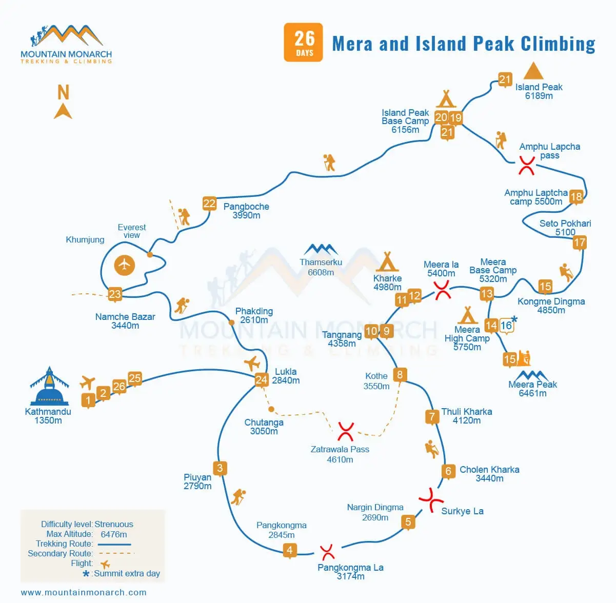
Map for a combined climbing journey to Mera Peak and Island Peak
Digital vs Printed Mera Peak Maps: Which one’s better?
Why choose? Experienced trekkers and climbers suggest carrying both the Mera Peak climbing printed maps and the Mera Peak trekking digital maps. Digital maps with GPS make navigation easier; you have real-time tracking of the trails, and they are also useful for backup. But at high altitude, batteries drain quickly, and electricity is often scarce, making the printed maps a more reliable option, including for the famous Annapurna Sanctuary Trek as well.
It is ideal for route planning discussions. You can find a wide variety of it on the online websites of several trekking and climbing agencies in Nepal, such as Mountain Monarch. We have the combined Mera and Island Peak Climbing package and maps as well to print and use, or you can visit the vibrant town of Thamel on the evening of your arrival day and buy one that suits you the best. Carry it with you all the time; pack it inside a water- and windproof shell.
Conclusion
The foundation of a safe and rewarding climb is understanding the detailed and updated Mera Peak route map from Lukla to Mera Peak Base Camp, High Camp Mera Peak, and finally to the Mera Peak height. Physically demanding, the Mera Peak trekking and climbing map allows trekkers and climbers better preparation, acclimatization, and navigation, which are keys to a successful ascent.
You stay aware of mountain conditions, terrains, and rewards that await, including potential risks like Mera Peak deaths, accidents, and injuries. These help transform the journey into an achievable Himalayan goal in one of Nepal’s most remote and iconic Himalayan valleys. In spring and autumn, there are fixed departures, including for the years 2026 and 2027, at Mountain Monarch. Contact us and reserve your seat now.
FAQs
Is there a difference between the Mera Peak Trek Map and the Mera Peak Climbing Map?
Yes, there are noticeable differences in trekking and climbing maps to Mera Peak. The trek map highlights the trails, villages, teahouse stops, and side trips as well as routes, while a map for climbing consists of glacier routes, high camps, and sections with fixed ropes.
Can beginners completely rely on a Mera Peak route map?
Yes, for navigation, novice or seasoned trekkers and climbers, everyone can greatly benefit from using the Mera Peak Trekking map, especially when you are on a guided Himalayan expedition. Well-trained, experienced, and licensed local guides ensure you stay on track and make the most out of the Himalayan voyage.
Are there alternative routes on the Mera Peak trekking map?
Several trek maps to Mera Peak also mention alternative routes such as Zatrwa La Pass and side treks and climbs to Everest Base Camp, Island Peak, or, if you want, the Lobuche East Peak Climb as well. Decide in consideration of your fitness level, stamina, and endurance at the moment.
How to prepare for climbing Mera Peak in Nepal?
Doable for beginners entering for the very first time into the field of mountaineering, it is, however, necessary that you are physically fit and possess a good level of physical fitness. So begin preparation at least two months before with cardio and activities that build stamina, strength, and endurance. More at How to climb Mera Peak? Everything you need to know.
What are the essential Mera Peak Climbing Permits?
You will need at least three permits to climb Mera Peak: the Sagarmatha National Park Permit, the local Khumbu Pasang Lhambu Rural Municipality Permit, and the climbing permit from the Nepal Mountaineering Association (NMA). Without these, your journey is considered illegal and may result in double the price and a ban from further entry.