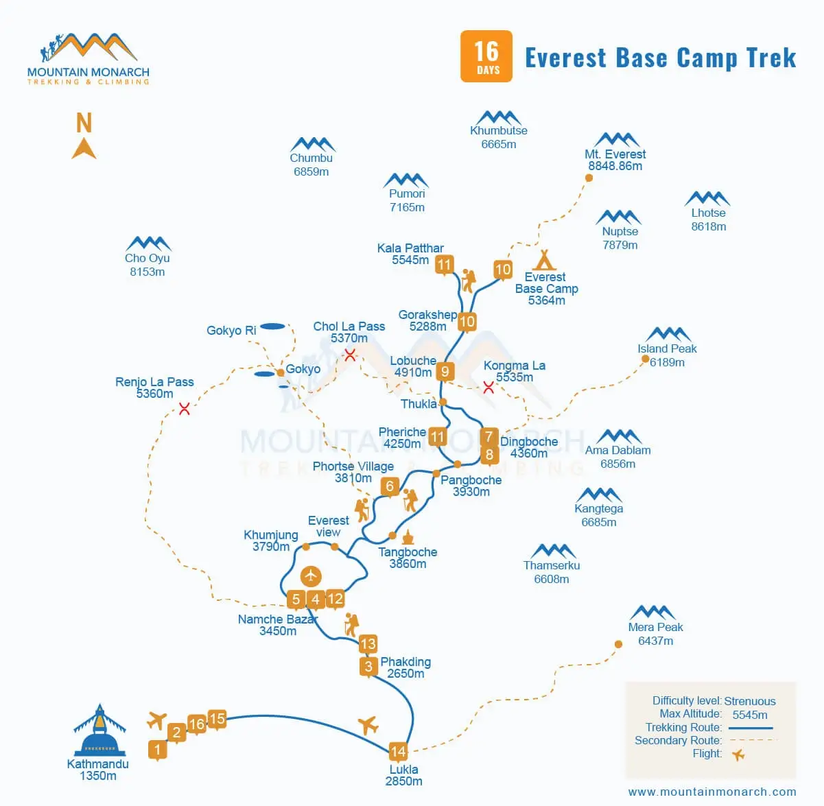
Map of Everest Base Camp Trek From: Lukla to Everest Base Camp with side trips
Map of Everest Base Camp Trek From: Lukla to Everest Base Camp with side trips
Updated on August 31, 2026
The Everest Base Camp Trek, with the opportunity to stand at the foot of the world’s highest peak, Mt Everest (8,848.86 m), is a dream adventure for thrill seekers worldwide. Through the iconic Khumbu Valley, part of the Sagarmatha National Park, a UNESCO World Heritage Site in Nepal, usually reaching the highest point at around 5,545 m above sea level at Kala Patthar, this Himalayan trip ensures you a life-changing experience, including for the years 2026 and 2027.
Especially when you have a proper outline of where you are going, and it is what the detailed Everest Base Camp Trek map ensures you of. Officially, hiking begins from Lukla; understanding the map of the Everest Base Camp Trek from Lukla to Everest Base Camp with side trips is a great help to plan an enjoyable journey from start to end. Also, mentioning the key Everest region landmarks ensures you do not miss any of the major highlights.
Understanding the Everest Base Camp Trekking Trail
16 days is the standard Everest Base Camp hiking itinerary that we at Mountain Monarch are offering. 20+ years of experience in crafting memorable Himalayan holiday packages, from day tours to multi-day treks and long expeditions, including the Manaslu Expedition, Baruntse Expedition, and the Everest Expedition, with premium services whenever available. We prioritize your safety, well-being, and satisfaction.
One of the keys to it is proper acclimatization to high altitude, and the 16-day Everest Base Camp Hike Itinerary, starting with trekking from Lukla, progressing through Phakding, Namche Bazaar, Dingboche, Phortse, Lobuche, and Gorak Shep, and finally to Everest Base Camp, guarantees this. It is also so that the journey is manageable even for beginners with a good level of physical fitness and also balanced cultural and natural exposure.
What is the Everest Base Camp Trekking Map for Beginners?
Rated moderate in terms of difficulty, including several days of high-altitude trekking, especially 3,000 m above sea level, where the level of oxygen present in the air drops significantly, increasing the risk of altitude sickness. Yes, you got it right; the high Himalayan trip to Everest Base Camp is manageable for first-timers. But unlike seasoned trekkers, the unfamiliarity with the Himalayan terrain may cause extra panic for beginners.
Even when the route is well established, it is where the Everest Base Camp trekking map for beginners becomes extremely essential. The trek map of Everest Base Camp highlights the daily trekking sections, elevation profiles, acclimatization stops, teahouses, villages, major viewpoints, alternative routes in case of emergency, and also rivers and suspension bridges. When you know all of these, you have better preparation.
Everest Base Camp Trek Map with Distance
While the exact distance covered during the hike to the Everest Base Camp does vary greatly based on the specific route chosen with side trips and extensions such as to Gokyo Lakes, Island Peak, and others, if you are sticking strictly to the standard one, you trek around 130 km (80 miles) from Lukla and back. Every day is a 5-7 hour walk, covering 8 km - 15 km, which, below 3,000 m above sea level, should be pleasing for anyone who enjoys long walks.
However, when there is a mix of steep ascents, descents, and rugged terrain, especially with an increase in altitude, it can feel tougher. Starting from roughly around 2,860 m to reaching 5,364 m at Everest Base Camp (EBC) and about 5,545 m - 5,644 m at Kala Patthar, the net elevation gain is around 3,000 m on one-way ascent. What adds to the challenges is the remoteness of the region and the limited access to quality health and other facilities. In a brief:
Day 3: Fly from Kathmandu to Lukla and trek to Phakding
It is the day when the Everest trek to reach Everest Base Camp (5,364 m) officially begins. A short yet scenic flight of 25 - 35 minutes to Lukla, often directly from Kathmandu, during peak trekking seasons from Ramaechhap, Manthali. Thereafter, you trek, and today you arrive at Phakding, which is about an 8 km (5 miles) walk of 3 - 4 hours. It is easy and perfect for warming up, passing by the small villages like Chheplung and suspension bridges over the Dudh Koshi.
Day 4 - 5: Trek to Namche Bazaar via Phakding and Acclimatization Day at Namche Bazaar
These are some of the most significant trek days on every Everest Base Camp Trek map when you finally make it to the Sherpa town called Namche Bazaar from Phakding, which is approximately 11 km (6.83 miles) away and about 6 - 7 hours of walking past Monjo village, the entry point of the Sagarmatha National Park, followed by the Hillary Suspension Bridge. On the next day, you do an early morning hike and explore the area for acclimatization.
Everest View Hotel, Khumjung, or Kongdae, all with far better mountain views than from the previous Everest trails, or, if extremely fatigued, rest as much as you want; the least you could do is explore the traditional vibrant Sherpa town, an ancient salt trade route.
Day 6 - 8: Hike to Dingboche via Phortse and Acclimatization Day at Dingboche
From Namche Bazaar, now at first follow the quieter Everest Trekking Trail via Phortse instead of Tengboche (about 12 km—6 hours). At the center of Ama Dablam, Thamserku, and other Himalayan peaks, above 4,000 m sea level, entering the Upper Khumbu Valley, the crisper air and open valleys also come with a sense of adventure, especially when you make it to Dingboche (12.5 km, 6-7 hours of walking) and spend an extra day adapting.
It is along the Imja Khola River, and now the lush forests of rhododendron give way to the alpine meadows from the tree line. Thereafter, on the next day, you hike to Nagarjun Hill or Chhukung Valley for acclimatization from Dingboche.
Day 9 - 10: Hike to Lobuche, then to Gorak Shep, Everest Base Camp, and Back
When you leave Lobuche behind, a dramatic alpine landscape becomes more vivid, including passing through the Thukla (Dughla) pass, famous for a memorial site in honour of brave trekkers and climbers who could not make it back. The trek covers a distance of 5 km (8 miles) and takes about 5 - 6 hours of walking. Then, the next day is a short hike to Gorak Shep (5 km/2.5 - 3 hours) and then finally Everest Base Camp (3.5 km/2 - 3 hours).
Often flocked with mountaineers in the peak trekking and climbing seasons of spring and autumn, preparing for the big day, the Everest summit, experience the high adrenaline rush, a taste of mountaineering before getting back to Gorak Shep.
Day 11 - 16: Side Trip to Kala Patthar and retrace the EBC Trekking route
After the Everest summit itself, it is Kala Patthar that provides you the closest sights of Mt. Everest, especially stunning during sunrise and sunset. So early in the morning, you do a 3-4 km round trip to and from Kala Patthar in 2.5-4 hours, soaking in the serene golden hours when the region comes alive with the first rays of sunlight over the snow-capped mountain peaks. The experience is beyond explainable in words and Trek Map for Everest Base Camp.
Spending rewarding moments thereafter, you return to Gorak Shep, grab a breakfast, and begin descending through the same trail that you once ascended through to arrive at the Everest Base Camp (EBC) via Pheriche, Namche, Phakding, and Lukla, from where you take a flight to Kathmandu.
The standard Everest Base Camp trekking map
Everest Region Landmarks to Spot Along the Way
The detailed Everest Base Camp trek map is incomplete without mentioning the region’s major highlights, the Everest region’s landmarks. So, you won’t regret paying attention to the Hillary Suspension Bridge above the Dudh Koshi River, the Sagarmatha National Park (also a UNESCO World Heritage Site), Namche Bazaar (the Sherpa capital), and Tengboche Monastery (the largest Buddhist monastery of the region), best for a side trip.
So is the Thukla Pass with a memorial dedicated to mountaineers, Sherpas, and adventurers that high mountains claimed. Thereafter are the South Everest Base Camp in Nepal, situated at an altitude of 5,364 m above sea level, and the mind-blowing massive Khumbu Glacier and Icefall. Likewise, as also mentioned above, no Everest Base Camp Himalayan trip is complete without a short yet fruitful hike to Kala Patthar for an ethereal Himalayan panorama.
Unforgettable Optional Side Trips & Route Extensions
A comprehensive Everest Trekking Trail map also suggests right side trips and extensions so that you have a thorough experience, get adequate time for adapting to the challenging Himalayan surroundings, and have a greater view than following the classic trek trail to Everest Base Camp. From Namche Bazaar, to follow the golden rule of hiking up and sleeping low, an early morning hike to the Everest View Hotel or Khumjung Village is strongly recommended.
Then, when you stop by Dingboche for acclimatization, visiting nearby Nangkartshang Peak helps you prepare for what awaits you when you hike further into the Sagarmatha National Park to arrive at the Everest Base Camp, or also choose to go beyond Chukhung Valley, the climbing starting point for those eager to complete the Island Peak climb. Then there is Kala Patthar from Gorak Shep, and if there are a few more spare days, Gokyo Lakes serves as an excellent option.
Tips for Using a Trekking Map to Everest Base Camp
Even with the Nepal Everest Base Camp Trek map in hand, a little preparation can greatly enhance the entire trip, so why not? Of course, the digital map is better, but in the higher Himalayas, due to cold temperatures, the batteries can drain fast, so it is recommended that you carry a paper map. Stay aware of the altitude, learn the major landmarks, and follow acclimatization guidelines for smoother navigation and gradual adaptation.
The Map for the Everest Base Camp Trekking from Lukla to Everest Base Camp with side trips is a must-have in your backpack as part of the preparation and packing for everyone heading into the Everest Himalayas. Beginners, seasoned adults, young adults, or families with kids and aged members: the trek map to Everest Base Camp with distance, the detailed one, provides brief knowledge about what you are signing up for- an empowering journey, equally demanding.
It helps you build up the right mindset and physical fitness required for an epic Himalayan trip that is both safe and enjoyable. Or contact us now for better guidance. Share what your aims are that you wish to meet from the trek, travel, or tour in Nepal. A personalized journey is our guarantee. Book one of our comprehensive trekking packages or customize; we are here 24/7 and strive to ensure you have a hassle-free, memorable escape in the serene Himalayas.